MyTransit NYC Subway & Bus MTA
- 4.6
- Rating
- 1.00M
- Installs
- Free
- Price
 Analysis by App-foxy
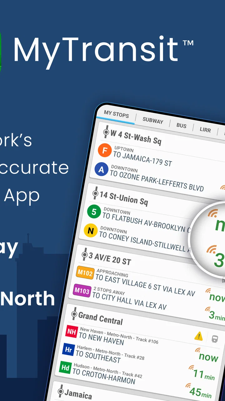
I use transit apps differently from ordinary map apps: I want a quick answer about the next train or bus, a map I can trust when I am underground or on an unfamiliar street, and enough detail to make a practical decision before I leave. MyTransit NYC Subway & Bus MTA is built specifically around that New York routine. It covers the city subway and bus network, while also bringing together Long Island Rail Road and Metro-North information, so it feels more focused than a general-purpose map when the trip is mainly about MTA services.
That focus is the reason I would recommend it to a friend who regularly moves around New York. It is not trying to be a universal travel planner for every city. Instead, it puts the local network first: routes, maps, and departure information in one place. The app is made by MyTransit™, belongs to the Maps & Navigation category, and has been available since February 12, 2012. That long presence matters to me because a transit tool becomes more useful when it is designed around one network rather than constantly switching between unrelated cities and transport systems.
What the app offers before you spend anything
The clearest part of the value proposition is the starting price: the app is free to download and use. That makes it easy to test during a normal commute instead of committing money before knowing whether its layout suits you. There are also in-app purchases ranging from $0.99 to $8.99 per item, so the free entry point should not be confused with every possible option inside the app. I would begin with the free experience and only consider a purchase if it solves a specific annoyance in my own routine.
You May Also Like

 Blood Strike: 2.5 Anniversary
Blood Strike’s Loadouts Turn Every Drop Into a Tactical Gamble
A close look at Blood Strike’s custom loadouts: how fast access to signature weapons reshapes its battle royale rhythm, rewards preparation, and narrows the gap between fights.

 Pandora - Music & Podcasts
Pandora’s Music Is Easy to Start, but Harder to Recover
Pandora’s strength is its low-effort path from a seed to a station. Its weak spot is how much confidence it asks you to place in connection, setup, and quiet recovery.

 8 Ball Pool
 Is Built on Rivalries, Rematches, and Routine
A close look at the rivalries, rematches, shared routines, and unanswered safety questions that turn a quick pool match into a persistent mobile community.

 Samsung Music
’s Quiet Strength Is Playing What You Already Own
Its reach comes less from spectacle than from dependable access to a personal library. That simplicity is both the app’s strongest retention engine and its ceiling.

 AccuWeather: Weather Radar
AccuWeather Review: A Quick, Clear Forecast for Everyday Decisions
For everyday plans, the best forecast is the one you can understand quickly. AccuWeather makes rain timing, radar, and local conditions easy to act on, with a few trade-offs.

 Hill Climb Racing
Why Hill Climb Racing Still Turns Crashes Into One More Run
A tiny car, a bumpy hill and one more upgrade: Hill Climb Racing keeps resurfacing because its simple chaos makes every near-miss feel personal.
More From Our News Desk



I appreciate that distinction because transit apps are often judged in a hurry. Someone standing on a platform does not want to study a complicated pricing model before checking a departure. Here, the sensible approach is to install it, search the routes you actually use, inspect the maps, and see whether the information is presented in a way you can read quickly. The free access gives commuters, visitors, and occasional riders a low-risk way to make that decision.
The app is rated for Everyone, which makes it broadly approachable for families and travelers sharing a phone. It currently appears as version 3.16.16 and requires Android 6.0 or later. Those details are especially relevant if you are installing it on an older Android handset kept for travel or used by a relative. I would check the device before planning a trip around it, because a transit app is not useful if the phone cannot install the current version.
Its public reception is strong: it holds a 4.6 average from roughly 36 thousand ratings, with about 8.9 thousand written reviews and more than a million installs. I do not treat those figures as proof that every rider will love the interface, but they do suggest that the app has reached a substantial audience and has been useful to many people. For me, the more important test remains whether it handles my particular combination of subway, bus, LIRR, or Metro-North travel without making me jump between several tools.
A focused alternative to a general map
Google Maps and Apple Maps are usually better when I need a complete door-to-door journey involving walking, restaurants, addresses, and several unrelated transport providers. They are familiar, broad, and convenient for visitors. MyTransit takes a narrower approach. When I already know that my trip depends on the New York MTA system, a dedicated app can reduce the visual competition from driving directions and general location results.
That difference is more important than it first sounds. A general map is designed to answer “how do I get anywhere?” A dedicated transit app is better suited to “which part of this network should I check right now?” If I am deciding between a subway route and an MTA bus, I want the network presented as the main subject, not as one layer among many. For LIRR or Metro-North journeys, having those rail services included also makes the app more useful than a subway-only reference.
The trade-off is that specialization can feel limiting outside the MTA world. If my itinerary includes a long walk, a rideshare, a regional connection beyond the covered services, or a destination where accessibility details are crucial, I would still keep a broader map app available. I see MyTransit as a strong transit companion rather than a complete replacement for every navigation tool on my phone.
How I would use it on an ordinary day
Imagine leaving work in Manhattan for a home reached by a subway connection and then a bus. I would open the app before walking to the station, check the relevant subway map and departure information, and then use the bus details to decide whether to board immediately or walk to another stop. That small decision is where a dedicated tool earns its place: it keeps the trip centered on the transit network instead of making me reconstruct the route from several separate searches.
For a visitor, the same workflow works in reverse. I would first look at the map to understand the broad shape of the route, then check times closer to departure. I would not rely on a map viewed once at the hotel for the entire day. Transit conditions change, and a responsible habit is to refresh the information before leaving and again when a connection matters. The app can help with the planning step, but it does not remove the need to pay attention to station signs and announcements.
One useful habit is to separate route learning from departure checking. When I have time, I use the map to understand where a line goes and where a transfer sits. When I am already late, I skip the broad exploration and go directly to the service and time I need. This prevents the common mistake of staring at a full network map when a simple next-departure answer would be more helpful.
Maps are useful for orientation, not just trip planning
Many riders open a subway map only when they are lost, but I find it more valuable before the journey. Looking at the network first helps me notice whether a seemingly short trip requires a transfer or whether a bus might be a better final connection. It also gives me a mental backup if a planned route becomes inconvenient. I do not need to memorize every station; I only need to understand the line, transfer point, and direction.
This is particularly helpful when traveling with someone else. Instead of passing around a general map filled with unrelated roads and businesses, I can show the transit structure and explain the plan in plain language. For families, that can make a complicated trip feel manageable. For visitors, it reduces the chance of boarding a train based only on the name of the destination without checking the route direction.
There is also a practical benefit to keeping the app available during a trip. If I change my destination halfway through the day, the dedicated MTA focus gives me a quicker reference than relying on memory. I would still verify the platform and service notices in the station, but the app is useful for rebuilding the outline of the journey instead of starting from nothing.
Where the value becomes less certain
The free price is attractive, but I would not automatically pay for an in-app item just because I use the app often. The listed purchase range tells me that optional paid value exists, not exactly which purchase is worthwhile for my needs. My rule would be simple: use the free version first, identify a repeated problem, and only then decide whether a paid option addresses it. Without that personal test, spending can turn a convenient free tool into an unnecessary expense.
I also think a dedicated transit app requires more user judgment than a fully guided navigation service. A general map may be better at combining walking instructions, addresses, and multiple transport modes into one continuous sequence. MyTransit’s strength is the MTA network itself, so I would not expect it to replace every part of a city-navigation workflow. Someone who wants turn-by-turn walking guidance from their front door to a precise entrance may prefer a broader alternative.
Another trade-off is information density. Subway, bus, LIRR, and Metro-North details can be valuable, but a newcomer may initially find a network-focused interface less immediately obvious than a familiar map app. I would spend a few minutes learning where the map and time views are before relying on it during a rushed transfer. That small preparation is worthwhile, but it is still a step that some casual users may not want.
Transit timing should also be treated as guidance rather than a guarantee. Even when an app shows a useful departure, I would leave room for platform changes, delays, crowding, and the time needed to reach the stop. My practical approach is to use the displayed time to compare options, not to arrive at the station at the last possible second. This is especially important when a missed connection would affect a work shift, appointment, or airport journey.
Small workflows that make it more useful
- Check the map before checking the clock. First understand the line and transfer, then look at departure times. This avoids choosing a fast-looking service that is awkward once the full route is considered.
- Use it for the network decision and a broader map for the last mile. MyTransit can be the MTA specialist, while a general map handles walking directions to an unfamiliar building or entrance.
- Refresh before a critical connection. A time checked at home may not be the best information after a delayed walk, a missed bus, or an unexpected change of plan.
- Keep a backup route in mind. When traveling across boroughs or combining subway and bus service, knowing one alternative line or transfer can be more useful than repeatedly searching the same route.
These habits also clarify who should skip the app. If you live outside the New York MTA area, its specialized coverage will not justify taking space on your phone. If you only need occasional walking directions, a general map may be simpler. And if you want one tool that combines every transport provider, detailed pedestrian guidance, and broad destination search, MyTransit may feel too focused.
Who is most likely to get real value
I think regular New York commuters are the best match. Someone who repeatedly uses the subway and buses benefits from having the network presented directly, rather than searching the same services through a general map every morning. The inclusion of LIRR and Metro-North also helps riders whose routines cross from city transit into regional rail. For those users, the app can serve as a dedicated reference point for planning and checking the parts of the trip that matter most.
Visitors can benefit too, especially if they are willing to learn the map instead of expecting the app to make every decision for them. I would recommend it to a traveler who wants to understand the MTA layout, compare a subway and bus option, and keep a transit-focused tool ready during a multi-day stay. It is less compelling for a visitor whose schedule is mostly walking, taxis, or destinations outside the covered network.
Students, occasional commuters, and families may also appreciate the free starting point. They can test it around a familiar trip and decide whether the interface makes transfers easier to understand. Since the age rating is Everyone, it is suitable as a shared planning tool, although the person using it should still teach younger riders how to confirm the station, direction, and stop rather than following a screen blindly.
For a professional who cannot tolerate uncertainty, I would use it alongside official station information and a backup plan. The app can reduce planning friction, but no phone tool should be the only source consulted when a missed train has serious consequences. That is not a criticism unique to this app; it is a sensible boundary for any live transit reference.
My buy-or-skip verdict
I would install MyTransit NYC Subway & Bus MTA if my travel is centered on New York subway or bus service, especially when LIRR or Metro-North may also be part of the journey. The free access makes the decision easy, and the focused coverage gives it a clear reason to exist beside Google Maps or Apple Maps. I particularly like the idea of using it for the network view and departure check, then switching to a broader navigation app only when I need detailed walking guidance.
I would skip it if I rarely use the MTA system, need worldwide navigation, or prefer one general-purpose app for every stage of a trip. I would also avoid paying for optional items until I had used the free version long enough to understand exactly what improvement I wanted. The purchase range of $0.99 to $8.99 per item is reasonable to note, but it is not a reason by itself to spend.
Overall, my opinion is positive because the app is specific where specificity helps. It does not try to be the answer to every navigation problem; it concentrates on New York transit and gives that network the attention it deserves. If your everyday question is “how do I use the MTA from here?” this is a practical free app to try before paying for anything. For me, that focused purpose, established presence, and broad transit coverage outweigh the need to keep a general map app for walking and non-MTA parts of the journey.
FAQs for MyTransit NYC Subway & Bus MTA
01What is MyTransit NYC Subway & Bus MTA used for?
MyTransit NYC Subway & Bus MTA is designed to help riders navigate New York City’s subway and bus network. It typically provides route maps, station information, trip-planning tools, service alerts, and schedules for MTA transportation. Before downloading, remember that it is a third-party travel app, so features, data accuracy, and update speed may depend on the app developer and the availability of official MTA information.
02Does MyTransit NYC Subway & Bus MTA work offline?
Some parts of the app, such as subway maps or previously loaded route information, may remain available without an internet connection, which can be useful underground where cellular service is unreliable. However, live arrival times, current service alerts, trip changes, and real-time vehicle locations generally require mobile data or Wi-Fi. It is best to load your route before traveling and avoid relying exclusively on offline information.
03Does the app provide real-time MTA service updates and arrival information?
The app may offer real-time information for subway and bus arrivals, delays, planned maintenance, and route changes, depending on the data sources and the selected service. These updates can be extremely helpful during daily travel, but they should not be treated as guaranteed. Information may occasionally be delayed or unavailable because of connectivity problems, changes in MTA data feeds, or unexpected incidents across the network.
04Is MyTransit NYC Subway & Bus MTA free to download and use?
The application may be available as a free download, but some features can include advertising, optional purchases, or premium tools depending on the version installed and your device’s app store. Before downloading, check the current listing for subscription details, in-app purchase information, and privacy disclosures. Also confirm that your device meets the supported operating-system requirements for smooth installation and operation.
05Is MyTransit NYC Subway & Bus MTA an official MTA application?
MyTransit NYC Subway & Bus MTA should not automatically be considered an official Metropolitan Transportation Authority application simply because it uses MTA routes, maps, or service information. Third-party apps can provide convenient interfaces and useful planning features, but official policies, fares, accessibility details, and service changes should be verified through official MTA channels when accuracy is especially important. This is particularly advisable before airport trips, late-night journeys, or transfers affected by planned work.
Pros
- Real-time MTA subway and bus arrivals help reduce waiting uncertainty.
- Supports offline subway maps for navigating with limited mobile service.
- Covers multiple transit modes
- including subways
- buses
- and rail connections.
- Favorites make it quick to access frequently used routes and stations.
- Service alerts help identify delays
- closures
- and planned maintenance.
Cons
- Arrival predictions can be inaccurate during disruptions or heavy traffic.
- The interface may feel crowded for first-time users unfamiliar with NYC transit.
- Some features may depend on an active internet connection or location access.
- Frequent service changes can make route information temporarily outdated.
- Advertising or premium features may affect the overall app experience.

MyTransit NYC Subway & Bus MTA
Gallery